
Production of an Atlas for Hydrogeological Maps for: Alexandria –Greater Cairo – North Upper Egypt and North Middle Upper Egypt Regions (North Western Desert, Egypt) using Geographic Information Systems and Satellite Images
Researcher:
Prof. Dr. Salwa Farouk Al-Bey
Duty researcher:
Prof. El-Sayed A. Zaghloul
Summary of project:
Groundwater in Egypt exists mainly in the Nile Valley, Nile Delta, Western Desert, and Sinai Peninsula systems in addition to the Eastern Desert system. Groundwater is the only available resource for interdisciplinary development in the areas around the Nile Valley, because of insufficient rainfall. Groundwater in the Nile aquifer system and desert fringes is not a resource in itself as it is replenished from the River Nile by seepage from canals and deep percolation from irrigation and drainage applications (El Arabi 2012). Previous studies have indicated that groundwater is not a renewable resource and the use of this fossil water depends on the cost of pumping and potential economic return over a fixed time period (Allam et al., 2002).The largest groundwater storage is in the Nubian Sandstone Aquifer System (NSAS) underneath the Great African Sahara and spans the political boundaries of four countries; Egypt, Sudan, Chad and Libya (Alnaggar 2003).Integrated remote sensing and GIS are widely used in groundwater mapping where remotely sensed surface indicators of groundwater provide useful data where practical classical alternatives are not available. Data driven out of remote sensing, support decisions related to sustainable development and groundwater management.
The objective of the project:
The overall objective of this project is to update the hydrogeological data of Alexandria, Greater Cairo, North Upper Egypt and North Middle Upper Egypt Regions. The hydrogeological maps include water levels, salinity, hydrogeological units, and extraction. In addition, to produce the final output of the hydrogeological maps from a previous project executed by the National Authority for Remote Sensing and Space Sciences in collaboration with the Egyptian Geological Survey and Mining Authority for the capacity building of both organizations in cooperation with UNDP and UNESCO Cairo office (EGY/97/011).
The most important outputs:
Collecting all data on groundwater and surface water potentials in one volume (paper and digital database) that are easy to deal with so that it can be benefited from and updated whenever possible with the passage of time
Identify areas with high potential for groundwater development, which can support economic development and agricultural activities in the region.
Published two research papers in international peer-reviewed journals based on the data collected during the project on the potentiality of groundwater resources in specific areas
A collection of images that express the outputs
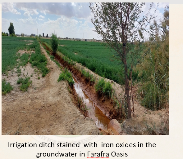
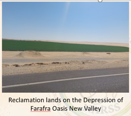
Examples of field observations
Latest Events
Latest News

NARSS
National Authority for Remote Sensing & Space Sciences
NARSS is the pioneering Egyptian institution in the field of satellite remote sensing. NARSS is an outgrowth of a Remote Sensing Center, established in 1971 as an American-Egyptian joint project that was affiliated to the Egyptian Academy of Scientific Research and Technology


