
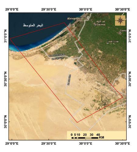
Sustainable of Land and Water Resources in Siwa Oasis, Using Remote Sensing Techniques
Researcher:
Prof. Dr. Alaa El-Din Hassan Al-Nahry
Summary of project:
The project aims to identify the land and water resources of Siwa Oasis, as this region is considered one of the state’s priorities, with all the technical and material capabilities the region possesses, by developing radical solutions to the problem of increasing salinity in the water of the “cracked limestone reservoir” as a result of the random drilling of wells, as this reservoir is considered the main reservoir. To produce irrigation water in the oasis, and also to solve the problem of increasing amounts of agricultural drainage water, which led to a rise in the ground water level in the agricultural lands in the oasis, which negatively affected these lands.
The study also aims to develop these resources and work on their sustainability through the use of spatial mathematical models that take into account the economic and social dimensions of the population while preserving their customs and traditions in dealing with land and water. These models included:
Applying multi- and hyper-spectral satellite visualization techniques to the study area - conducting an exploratory survey of the study area - conducting geomorphological studies of the study area - conducting soil studies of the study area - conducting a semi-detailed survey of the soil - studying the productive capacity of the land - studying the suitability of the land for growing specific crops - designing a model Mathematical analysis of land and water use priorities in the study area in accordance with the country's strategy for sustainable development.
The objective of the project:
Training the research team on hyperspectral space visualization techniques.
- Updating the soil map in the study area
- Using hyperspectral space visualization techniques
- Conduct a geomorphological study of the study area
- Designing spatial mathematical models for the productive capacity of the soil according to the conditions of the study area.
- Determining the suitability of soil for producing different crops.
- Design a model for prioritizing the use of land and water resources.
The most important outputs:
- Updating the soil map in the study area after completing physical and chemical analyzes of the soil and integrating data extracted from multi- and hyperspectral satellite visualizations.
- Designing spatial mathematical models for the productive capacity of the soil and the suitability of the soil for producing specific crops according to the conditions of the study area.
- Producing suitability maps for different crops according to the conditions of the study area.
- Design a model for priorities in the use of land and water resources that can be applied in other areas and research.
- Providing the decision maker with comprehensive information about the optimal exploitation of the study area.
A collection of images that express the outputs
Latest Events
Latest News
NARSS
National Authority for Remote Sensing & Space Sciences
NARSS is the pioneering Egyptian institution in the field of satellite remote sensing. NARSS is an outgrowth of a Remote Sensing Center, established in 1971 as an American-Egyptian joint project that was affiliated to the Egyptian Academy of Scientific Research and Technology


